Şimdi Kapalı
Dara is located 30 km southeast of Mardin city, 18 km northwest of Nusaybin and 7 km north of the city of Amuda in Syria. Geographically Dara situated by the southern skirt of the Tur Abdin Mountains to the north of the Mesopotamian Plain and dominated the plain.
Name of Dara and Establishement of the City
It has been speculated that Dara was a military garrison of Darius III (336-330 BC) and the city named after him. The city, known as Dara, is referred in ancient Greek sources as “Daras”. It was first mentioned by ancient author Iustinus Frontinus, who lived in the 3rd century AD. He cited that the city founded by the King of Parth I. Arsakes:
“...Arsakes founded the Parth state, assembled soldiers, built castles and strengthened his cities. On Zapaortenon Mountain, he built a city called Dara, which could not be any place safer or nicer. Because there was no need to defend it, its position was surrounded by strong steep rocks and the products from the fertile soil around it were stored. There were a lot of resources fed by streams and so many woodlands that the hunt was full of all the pleasures of the pursuit.”
Dara changed hands from the mid-third century BC until the 1st century BC between Parth and Seleucid Kingdoms. Dara, a small settlement at the beginning of the 6th century AD, was chosen as the garrison city by the Eastern Roman Emperor Anastasius (491-518) and his construction activities were carried out in the city in the years 503-507. Anastasius gave his name to the city he founded (Anastasiopolis) and turned Dara into the administrative and military epicenter of the Mesopotamian Region.
During the Anastasius Period (491-518 AD) the city founded on the small village settlement due to the closeness to Nisibis (Nusaybin) the strategic and protected location of the region, proximity to water resources and the presence of a dominant place in the plains was the determining factor.
Dara was ruled by the Sassanid Empire between 577-591 and 606-620, and was dominated by the Eastern Roman Empire from 620 AD to AD 639.
A large part of Northern Mesopotamia came into Arab domination in 640 alongside Dara. In the 10th century, Dara, who entered the Eastern Roman Empire for a short time, changed hands between the Seljuk State and the Eastern Roman Empire until the end of the 11th century.
In 1150, Dara was sieged and conquered by the Artuqid ruler Timurtash and the entire Mardin became a town under the reign of the Artuqi Principality. Between 1251-1259, the town was largely destroyed by the Ilhanlı.
After this date, Dara was slowly abandoned and it was reduced into a small rural settlement by the 14th century.The present village of Dara was founded end of the 18th century and the inhabitants dwell on top of the remains of the majestic Roman city.
One of the most impressive building groups of Dara is the rock-cut tomb groups, carved directly on bedrock. The wide hills situated at the west of the town were used at the beginning of the 6th century as a stone resource for the building activities in the city.
The flat façades obtained after cutting out the stone were later converted into a necropolis area. On the hills extending to the west of the city, the deep and widely carved gorges on natural bedrock thus served as a cemetery. In this area, three different tomb types are to be found: Rock-cut tombs (6th century), sarcophagi (6-8th century) and simple cist-tombs (8-14th century).
During this period, the dead were buried into rock-cut chambers, in a belief of rebirth, honouring the god Mithras, believed to be born out of a rock in pagan and Mithras cults. In these chamber tombs, multiple burials were made by the people of Dara, who apparently did not lose their pagan beliefs for a while despite their conversion to Christianity.
Paganism is a very old belief system relying on respect to nature and sanctity of every soul living, be it an animal, earth, plant or rock.
A sarcophagus is for a Roman a home intended for afterlife. The soul of the deceased will be dwelling and protected in this home. The Roman sarcophagi were shaped based on this belief. With the traditionalization of Christianity, simple cist graves became more and more popular.
The most striking structure in the rock-necropolis area is a large three storey chamber carved completely on bedrock, with its plan and interior decorations.
The structure was oriented north-south and planned rectangularly. The upper storey was planned as a corridor/balcony that ran through the west, south and east edges. On the pediment of the monumental entrance gate situated at the north, religious scenes as well as floral ornaments were carved.
The grave gallery ornamented with religious scenes of reanimation such as the prophet Ezekiel (Zulkifl) reanimating the deceased, is believed to be built after the Sassanid invasion of 573, in order to commemorate the people dead in the invasion by the Eastern Roman population who returned from exile after 591.
During the excavation work conducted in 2009, hundreds of human bones were revealed in the lower storey of the building, which were apparently collected and buried into this grave area, in a belief of reanimation like with the miracle of Ezekiel.
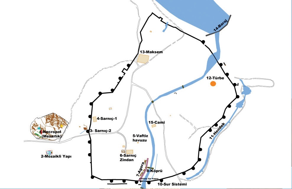
The fortification walls, encircling the three large hills on which the city was founded, were roughly 4 km long, 2.8 km of which can be followed by naked eye. As a result of the latest measurements, the average width of the walls were 3.70-3.80 m and the walls were built with smooth cut stones from the inside and outside. In Dara there are two fortification systems; the inner city walls and the outer walls and on these walls there are 28 towers located. There are also trenches/ditches about 20 m east of the east wall.
The imposing remains of the fortification belong to the period of Anastasius I (491-518) and Justinianus I (527-565). In 530, the height of the walls was raised to 29 m and a second storey was built in order to form crenulations and loopholes during the reign of Justinianus I. As a result of the recent excavations the highest level of the walls was measured as 15 meters.
The fortification system of the city has four main gates at four main directions. These gates are called the South, North, East and West Gate, in addition to those the North and South Water Gates are located in the arched sections where the Cordis (Kordes) River passes south and north of the city. The water enters the city from the arched opening in the northern fortification wall. This opening was covered with a double iron portcullis, which is still quite solid. On the south gate, where the water left the city, a similar structure was built.
There are large towers on either side of the gates that have four entrances to the city. These gate types are called as double-tower doors are generally examples to keep entrances safer. As a result of the measurements in the doors, the door widths were determined to be approximately 5 m. The water gates are 1.50 m wide and 3.70 m deep.
The street, which is furnished with large stone blocks from the south gate of the city, extends from 45-50 m to the north starting from the south door and is about 5.80 m wide. There is a portico along the western side of the avenue and the location of the street connected with the Silk Road, showing that the trade caravans coming from Mesopotamia entered this area and that the area is a public space reserved for the city's shopping. The city has a portico along the western side of the street that stretches along the river and the shops and ateliers on the west side of the street. The location of the street connected with the Silk Road indicates that the trade caravans coming from Mesopotamia entered the area and the area was a public space reserved for the city's shopping. Surveys made in areas such as fields and gardens in the north of this area indicate that the street continues to the north in parallel with the natural fold of the river. The street, which is furnished with large block stones, is about 5.80 m wide.
The east side of the the street in the city, that runs throughout the river, faces the stream while along the west side resides a porch and workshops behind it. As a result of the excavations in the Agora, 9 workshops and 6 residences linked with workshops were found. These workshops were side by side, adjacent to the Agora and stretching through North-South direction. They were mostly in square plan with 5 x 5 m dimensions. While the eastern wall was well preserved to this day, other walls of the workshops have been re-build in different periods.
The water system and cisterns aimed at storing water that flew from high mountains and redistributing it through channels to the entire town, were utterly important in the defence of the city. The city could resist sieges for a long time, especially when the outer contact was totally cut by Sassanid armies, thanks to these water sources. The Sassanids could not cross the walls of Dara and therefore by building sets on the Cordis River from Dara on the north, they expected that the people of Dara and Roman soldiers would be dehydrated and to deliver the city without fighting. However, the Roman soldiers, who stored the waters from the mountains into the cisterns used water as a weapon against Sasanis. With natural sources of water they could withstand these sieges for a long time.
The water collection/distribution chamber was built on the southern skirts of the acropolis, by carving on bedrock. The water had been carried into the city from the hills situated 4 kms to the north. The water collected was distributed through channels to main buildings and cisterns of the city.
This structure consists of ten cell-chambers covered with parallel barrel-vaults. Every cell is 50 m long, 4 m wide and 18 m high, with a capacity of 14.500 cubic meters.
This cistern is situated at the edge of the western fortification walls and possibly built in order to meet the water needs of the nearby buildings.
This cistern is built outside the main fortification wall, to the southwest of the previous cistern. It is thought that the cistern served commercial caravans hosted outside the city and to the necropolis area. The building is covered by a cross-vault, carried by two stone piers. 12 cubic meters of earth fill inside the cistern has been emptied out during the excavation work ran by our museum.
This is the large cistern remaining approximately 100 m to the northwest of the Agora Street. The original entrance of the cistern, built with regular ashlar, is on its eastern facade. Although the related buildings and auxiliary structures are still under earth and a house has been built on top of the cistern later on, the cistern still keeps its grandiosity. On top of the two-storeyed structure, there used to be the cathedral of the city. Today, only western wall is still standing.
According to the historian Procopius, there were two important churches in Dara. One of these was called “The Great Church” and the other one, “St. Bartholomew Church”. According to the historian Theodora Lector, St Bartholomew appeared in a dream of the emperor Anastasius I and asked him to protect the city. In return, Anastasius had the relics of St. Bartholomew carried from Cyprus to Dara. Until the 14th century, this cathedral was the center of the Assyrian Metropolite.
At the northeast of the Great Church, a well-preserved baptism basin is to be found (Plan no 35). This basin, built for baptising adults converted into Christianity, has steps at two sides. An adult entering the basin was supposed to be üpurified in the basin and when the ceremony ended, step out from the other side. The baptism symbolises a person’s death for their old sinful existence and to reborn for a new and pure life.
The translation of the Old Hellenic inscription is as follows:
Funded, founded and paved with mosaics, next to God, <from> the (monies) of our most pious and Christ-loving emperor Anastasios, at the command of the most distinguished Daethos, the most illustrious locum tenens of the Praetorian Prefect; and by the forethought of those who preside over the most sacred church of Amida, men most beloved of God; in the reign of Eutychian, the most holy bishop of Anastasioupolis, while the administrators of this (city) were the pious priests Abraham and Thomas, in the (Macedonian) month of Dios (October), Indiction VIII, of the year 826 (of the Seleucid Era), to the glory of God the Father and of his Anointed (or: his Christ) and of the Holy Spirit, Amen. Makimos (made this part of the mosaic).
This building is situated 50 km to the south of the rock-cut necropolis area. This building belonging to the period of Anastasius could still not be excavated completely, as it is standing on a private ground.
The rooms at the east of the building are paved with mosaics and the rooms are founded on a slope going down from north to south. On the mosaic composition, a pastoral scene with a shepherd, plants and animals is pictured, as well as an inscription of 11 lines in the middle. The inscription tells that the city dedicated to Anastasius has been founded with the help of the churches of Diyarbakır in 507.
The mosaic that has been discovered roughly 20 m north of the the Southern wall is approximately 8.5 x 7.5 m (56 m²) in dimensions. This is the floor mosaic of the structure with walls on four sides. A door of 1.2 m in width is situated on the north side of the structure.
Fish scale is the most commonly used pattern throughout the mosaic. Red and white are the only colors that were used. A plain border was used to contour around the mosaic and inside of the border was decorated with fish scales that were made from semi-circles. While the centres have red tesserai, white was used around the scales.
The tombs of the Chechens have been unearthed at the center portion of the Necropolis area, the tombs are dated back to the Russian Chechen War of 1870; Chechens migrated and settled in Dara and of a result of an epidemic illness most of them died and were buried here.In addition, there are many Muslim graves around the baldachin planned mausoleum which is located on the hill east of the city. These graves are thought to have been designated as a cemetery with Islamic conquests. Graves are dated to 7th and 14th century AD.
The tomb is built in Baldachin Style out of smooth ashlar. The dome covered tomb’s date and to whom it belongs is unknown, no inscription has been found related to the tomb. But according to the stylistic structures the tomb can be assumed to be a work of the 14th- 15th centuries.
 Restroom


Bu müzede etkinlik yok
Tüm Etkinlikler Müze Plan
 Müze Broşür
 Puan Ver